Coastal walks in Dorset
Penned on the 27th April 2022
Along Dorset’s Jurassic Coast you’ll find some of the UK’s most breathtaking landscapes, with its towering white cliffs, fossil-laden rocks, sweeping golden beaches and turquoise waters.
One of the best ways to appreciate this UNESCO site (the first and only one in the country) is, undeniably, by foot. A 95-mile section of the famous South West Coast Path runs along the county’s coastline, so there are ample options for walkers of all abilities and interests. Some are easy rambles, some are challenging climbs; some take in historic ruins and charming seaside villages, others wild cliff tops and hidden coves. But wherever you choose to set off on your hike, you can guarantee you’ll be rewarded with fresh sea air in your lungs and stunning panoramic views. In this guide, we’ve gathered a collection of the best scenic coastal walks that Dorset has to offer. Walking boots and cameras at the ready…
Studland Village to Old Harry Rocks
Difficulty: Easy
Distance: 3.9 miles
This circular clifftop walk at the eastern end of the Jurassic Coast is a wonderful way to take in the impressive chalky white cliffs that the area is famed for. Once upon a time, these spectacular limestone stacks were part of a band connected to the Isle of White, and on clear days you can see the only remaining rocks ‘The Needles’ in the distance. The far-reaching views extend to Swanage on one side and Bournemouth on the other, too.
The walk starts in Studland Village, then you’ll follow the coast path to the end of Handfast Point (where you’ll marvel at Old Harry Rocks) before looping around the headland and heading inland across Ballard Down. The terrain is mostly flat and easy underfoot but there is a short section of uneven ground and a slight incline.
It’s a perfect route for soaking up the beauty of nature all year round, but it’s especially lovely in the spring and summer months when the grasslands are abundant with colourful wildflowers, orchids and butterflies. Another small but notable highlight, and a quaint place to pause for a moment, is the limestone seat at the top of Ballard Down that dates back to 1852 and features a weathered inscription that once read ‘Rest and be thankful’ - a simple and beautiful reminder.
Once you’ve returned back to your starting point in Studland, the Bankes Arms pub is a welcome pitstop for a refreshing pint or hearty meal. Explore our list of the top spots to eat in Dorset to discover where else you can refuel during your stay.
Find out more about this route on the South West Coast Path’s website.
Lyme Regis to Charmouth
Distance: 5 miles
Difficulty: Easy to moderate
This popular circular walk takes you along the coast from Lyme Regis to Charmouth and back, and is the perfect place to absorb yourself in the Jurassic Coast’s rich geology and go on the hunt for fossils. It’s the birthplace of famous palaeontologist Mary Anning, making it a hotspot for it - whole skeletons have even been discovered here!
This simple route follows the South West Coast Path over the cliffs from the seaside resort of Lyme Regis to the delightful village of Charmouth, passing through peaceful woodlands that are awash with bluebells in the spring. You can walk back from Charmouth Beach all the way along to Lyme Regis, beneath the fossil-rich cliffs - just make sure you time it so that you’re returning at low tide because the beach can get cut off at high. The beach is rocky, so whilst it’s a simple route, it makes for slightly tricky terrain in places.
Once you return to Lyme Regis, refuel with some Asian street food from the well-loved Red Panda or a portion of classic salt-and-vinegar-laden fish & chips from Herbies.
Golden Cap
Difficulty: Moderate to challenging
Distance: 4 miles
Standing at 191 metres (627 feet), Golden Cap is the highest cliff on the south coast. It towers above the surrounding countryside and, as you’d expect, delivers some of the most awe-inspiring views in Dorset.
The circular walk begins in the small coastal hamlet of Seatown, from which it’s a one-mile climb to the summit along the waymarked South West Coast Path. It’s a steep path that’ll challenge even seasoned walkers - but it’s well worth the effort! When you reach the golden orange sandstone peak that gives Golden Cap its name, beyond the patchwork of green fields you’ll be rewarded with vast ocean views across Seatown, Charmouth and Lyme Regis. It’s a lovely place to stop for lunch, so make sure you pack a light picnic.
When you’re ready to descend, the route follows the path down the coast and then inland where you’ll encounter the romantic ruins of St Gabriel's Chapel, as well as beautiful woodland, flora and fauna, before returning back to Seatown.
This helpful guide outlines the full route in detail, so you won’t get lost once you venture off the Coast Path.
Before you head back to your hideaway, treat yourself to a handmade gelato at Baboo Gelato. It’s a 5-minute drive away to Morcombelake but their many awards prove it’s definitely worth the detour.
Lulworth Cove to Durdle Door
Difficulty: Easy
Distance: 2.5 miles
Arguably the most beautiful walk along the Dorset coast, this linear walk is certainly one of the most photographed. Over 200,000 walkers tread the trail every year, making it the busiest stretch of the South West Coast Path! Plan your visit out of season or early in the morning to get the best out of it.
It’s easy to see why this stretch is so popular. The walk begins above the picturesque seashell-shaped Lulworth Cove and follows the Coast Path along the dramatic cliffs to Dorset’s most iconic (and must-see) landmark, Durdle Door. This impressive natural limestone archway has been gradually eroding from the cliff for millions of years, leaving a striking silhouette that’s famous all over the world.
The undulating path is just over a mile so the walk only takes around 30 minutes each way, but you could easily spend a lot longer exploring the golden arc beaches looking for fossils, or wild swimming in the glittering sea.
There are plenty of choices for eating out in Lulworth once you get back there too, from quaint tea rooms to traditional pubs.
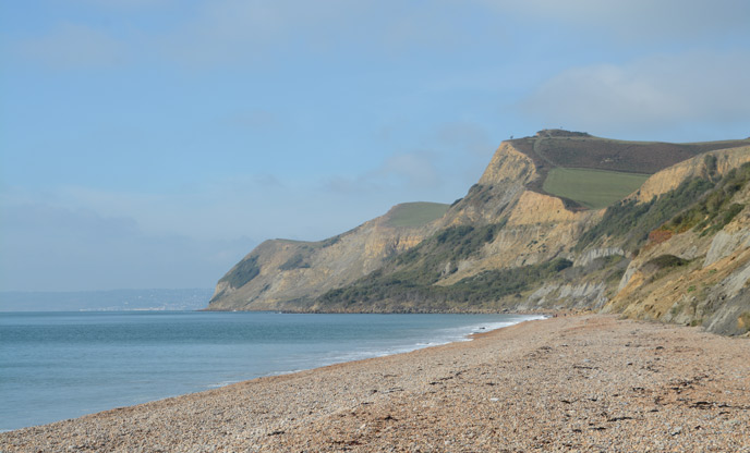
West Bay to Hive Beach
Difficulty: Moderate
Distance: 5.3 miles
The cliff faces along this stretch are sandstone rather than the chalky white limestone you find elsewhere on the Jurassic Coast, and if you visit in the early morning or late afternoon light, they glow in a heavenly gold colour, making for stunning scenery and photographs. It’s also of fascinating heritage, playing an important role in the preparations of the D-Day landings in the Second World War.
The circular loop begins at West Bay, overlooking the beginning of the rugged, 18-mile-long Chesil Beach. Follow the signposted path across a golf course and fields towards Hive Beach at Burton Bradstock. If you’re hungry, stop for some fresh local fish on the decked terrace at the excellent Hive Beach Cafe, before beginning the return walk back along the golden cliffs.
Most of the route is undulating but there are a few short and steep ascents that’ll get your heart rate up! Visit the South West Coast Path website for more details on the route.
Hengistbury Head
Distance: 3.7 miles
Difficulty: Easy
This accessible, short circular walk at Hengistbury Head near Bournemouth takes in beaches, heathland, marshes and woodlands, as well as a 360 panoramic view from the headland - and all in under 4 miles.
The walk follows the Stour Valley Way, a long-distance route that starts in Wiltshire and is well signposted along the way. You’ll start at the far end of Hengistybury Head, following the coast along to the highest point of the headland where you’ll enjoy sweeping views from Mudeford, to Christchurch, to Old Harry Rocks and The Needles at the Isle of Wight.
The walk continues to Mudeford Sandbank, famous for its brightly painted beach huts. Wander the windswept dunes along the sandbank before carrying on towards Christchurch Harbour, along wooden bridges and marshland, keeping an eye out for local birdlife such as little egrets, snipe and redshank. A tree-lined path takes you back to your starting point where you can learn more about the local wildlife and geography at the wonderful Visitor Centre, if you wish.
The Purbeck Ridgeway
Distance: 12.5 miles
Difficulty: Challenging
As well as vistas over Poole Harbour, Swanage and the Isle of Wight, this charming route takes in the enchanting ruins of Corfe Castle, steeped in over a thousand years of history. The dramatic site stands on a natural hill overlooking the village with the same name, and it’s a wonderful place to explore before you set off on your walk.
From Corfe Castle, the challenging linear hike traverses spectacular landscape along the Purbeck Way before joining the South West Coast Path down into the nostalgic coastal town of Swanage. If it’s running, take the 20-minute train on the heritage railway back to Corfe Castle for a romantic return journey. Timetables vary so check before you travel.
The National Trust Tea Room is a cosy place to enjoy a meal or a coffee and cake once you arrive back at your starting point.
Read about the route in more detail on the South West Coast Path website.
Burton Bradstock to Ferry Bridge
Difficulty: Challenging
Distance: 17 miles
At 17 miles this is by far the longest walk on our list - but it actually has the least elevation gain, so it’s achievable for those with a moderate level of fitness. It’s an underrated stretch of the coast too, that’s usually a lot quieter than the well-known trails and passes through a variety of stunning scenery and unspoiled countryside.
The linear walk starts in the pretty village of Burton Bradstock. Follow the coast path along to the remote Cogden Beach (part of the larger Chesil Beach) where you’ll trek along the edge of the shingles. A 6-mile stretch takes you past West Bexington beach towards the historic Abbotsbury, before going inland to bypass Fleet Lagoon, the largest lagoon in England and home to large numbers of birds and other wildlife - take binoculars if you can.
The scenery changes to woodland and farmland fields, and nearby charming villages on a wiggly route all the way along to Fleet and then finally, Ferry Bridge. Neither a ferry or a bridge, despite the name, this is the place where the Fleet Lagoon meets the sea, the point where Weymouth leads on to the Portland Beach road and the historic point of crossing to the Isle of Portland.
Head to the laid back diner Billy Winters for a pizza or a burger by the water, before getting a taxi back to your starting destination of Burton Bradstock (around a 25-minute journey).
It’s a full day out and a decent stretch of the legs… you’ll be sure to sleep well!
Scratch Arse Ware and Dancing Ledge
Distance: 3.5 miles
Difficulty: Moderate
There are lots of amusingly named places in Dorset and we couldn’t write a guide to walks here without including this one, which is perhaps the best of all! ‘Ware’ is a local word for land used for rough grazing, and it’s been suggested that the name of this particular one derives from the large amounts of scratchy gorse that grows here. We’ve not only included this walk for the name though - it’s a beautiful route passing through lush meadows and grasslands, with stunning views of the ocean and craggy cliffs.
This ramble takes you from the village of Langton Matrevers, along Scratch Arse Ware and down well-trodden lanes to the popular Dancing Ledge, a flat rock at the foot of the cliff that was once used as a drop-off for shops collecting Purbeck limestone from the nearby quarries. This name is thought to be so-called because of the waves that bob and ‘dance’ over the ledge at certain stages of the tide. The ledge is also home to a small puffin colony - you might spot them if you’re patient, lucky and visiting during spring. Once you’ve enjoyed some time there, the route heads inland back to your starting point at Langton Matravers.
You’ll encounter a few ascents and descents along the way, but it’s mostly fairly accessible grassy or stone terrain. Plan your route here.
If you’ve worked up an appetite (which we're certain you will have) call into The Square & Compass at nearby Worth Matravers for a traditional pint of ale or cider and a hot pie before heading back to your hideaway.
Staying in Dorset

If you’re looking for the perfect base for a wonderful week of coastal walks in Dorset, we’ve got a lovely collection of glamping accommodation to choose from. How about a luxury French-style shepherd’s hut, nestled in the idyllic countryside?